Fire Hazard Severity Zones (FHSZ) & Local Responsibility Areas (LRA) Updates
The recent updates to Fire Hazard Severity Zones (FHSZ) in California provide a more precise assessment of wildfire risks using modern climate data and advanced fire modeling. These updates impact the Local Responsibility Areas (LRA), influencing fire prevention measures, including defensible space, building codes, and real estate disclosure requirements.
Local Responsibility Areas (LRA) – 2025 FHSZ Updates
On March 24, 2025, OSFM issued the 2025 Recommended Local Responsibility Area (LRA) FHSZ maps for Riverside County.
LRA 2025 FHSZ Map Changes
According to Government Code Section 51179 (b)(3):
- Local agencies shall not decrease the FHSZ level recommended by OSFM.
- Local agencies may add to or increase the recommended FHSZ level, but Riverside County Fire Department is not proposing any additions or increases during this adoption process.
2025 LRA FHSZ Adoption
Per state law, Riverside County Fire Department must adopt the OSFM-recommended LRA FHSZ maps by ordinance within 120 days of their release.
Key Takeaways
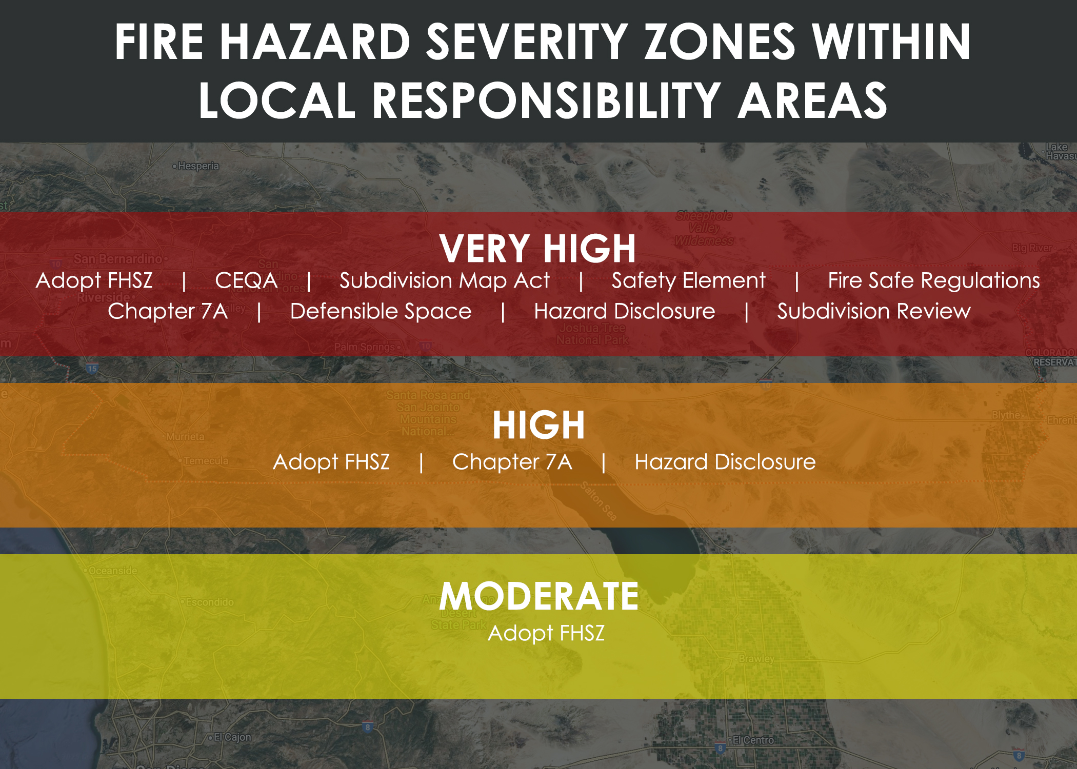
FHSZ Classification
Properties are designated as Moderate, High, or Very High Fire Hazard Severity Zones based on:
- Terrain and topography
- Vegetation and fuel conditions
- Fire history and frequency
- Climate and weather patterns
Fire Hazard vs. Fire Risk
FHSZ maps identify the hazard potential, not the immediate risk. They do not factor in mitigation efforts such as defensible space, fire-resistant construction, or local firefighting capabilities.
Impact on Property Owners
Homeowners in Very High FHSZ must:- Maintain 100 feet of defensible space around structures.
- Comply with home hardening requirements to reduce ignition risks.
- Ensure new construction and renovations adhere to Wildland-Urban Interface (WUI) building codes.
- Disclose FHSZ designation when selling property.
- Comply with home hardening requirements to reduce ignition risks.
- Ensure new construction and renovations adhere to Wildland-Urban Interface (WUI) building codes.
- Disclose FHSZ designation when selling property.
Legislative Updates
Senate Bill 63 (2021) – Expanded fire hazard oversight to include Moderate and High zones in addition to Very High FHSZ classifications.
Assembly Bill 337 (1992) – Originally mandated the identification of Very High Fire Hazard Severity Zones following destructive wildfires.
Assembly Bill 211 (2022) – Requires local agencies to adopt Moderate, High, and Very High FHSZ designations within 120 days of OSFM recommendations. Local governments cannot downgrade state-designated hazard levels but may increase them if justified.
Mapping & Compliance
- The Office of the State Fire Marshal (OSFM) updates FHSZ maps, which are used to enforce fire safety regulations statewide.
- Residents can check their property's FHSZ status online: RVC FHSZ MAP HERE
- Local jurisdictions must review and adopt the updated maps to enhance community wildfire preparedness.
2025 LRA FHSZ Maps Viewing
The OSFM 2025 Recommended LRA FHSZ Maps can be viewed here RVC FHSZ MAP HERE
Note: Some cities provide their own fire protection services. For LRA FHSZ maps and adoption information within the cities of Blythe, Calimesa, Canyon Lake, Cathedral City, Corona, Hemet, Murrieta, Palm Springs, and Riverside, please contact those cities directly.
Additional Resources
California Fire Hazard Severity Zone Website
CAL FIRE LRA & FHSZ Fact Sheet & FAQs
California Department of Insurance: Fire Hazard Severity Zones & Insurance Impacts